Products
National Geographic Maps RE01020610 Shipwrecks of the Northeast Wall Map - Laminated
Upgrade to unlock this product- Shipping Cost (lower 48): $15.87
- SKU: NAGGR351
- Asin: B008C83VJO
- Manufacturer Part #: RE01020610
- Qty Available: 736
- Shipped By: 4 days
- Stock: In Stock
Please login to view pricing details.
Product Description
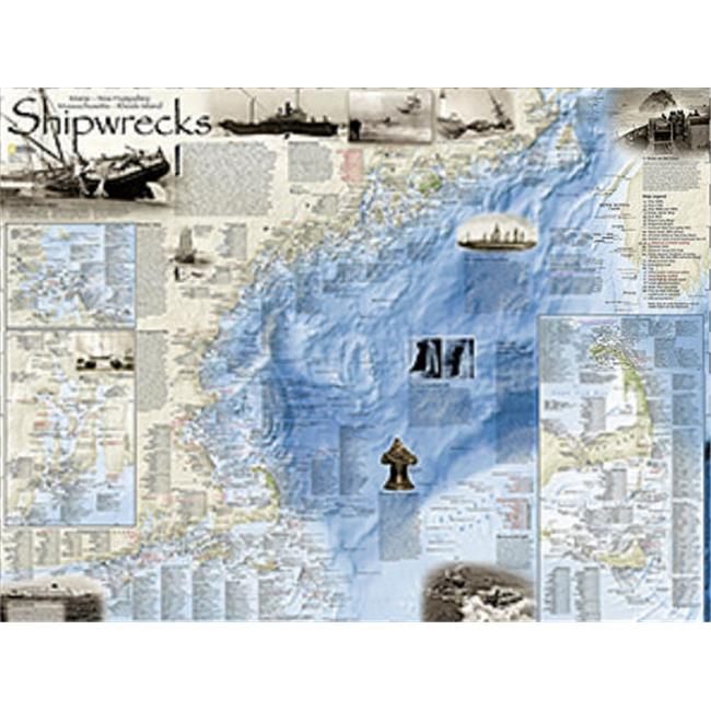
Developed by renowned marine archaeologist and accomplished author Don Shomette and designed by award-winning cartographer Robert Pratt, �Shipwrecks of the Northeast� is a stunning new map illustrating more than 5,400 known shipwrecks on the untamed Atlantic coast of New England (Maine, Massachusetts, New Hampshire and Rhode Island).
From Rhode Islands' Narragansett Bay to Maine's St. Croix River, the shipwrecks are clearly marked atop beautiful bathymetric and coastal detail. Each wreck site is symbolized to define the class, type and name of vessel accompanied by the date of sinking. Icons also indicate whether a ship was lost due to conflict or natural causes.
Shipwrecks of the Northeast is available for purchase in four different versions: rolled, rolled in a clear plastic presentation tube, folded in a polybag or laminated in a polysleeve bag. Each map is printed in the U.S. on high-quality 80# paper, printed with environmentally-friendly low VOC inks.
 upgrade to unlock this product
Raised Relief Map K-SF2225 San Francisco Bay
upgrade to unlock this productRaised Relief Map 419 Yellowstone National Park
upgrade to unlock this product434 World Geo-Physical Map
upgrade to unlock this product436 Ocean Floor Map
upgrade to unlock this productProducts 448 Middle East Map
upgrade to unlock this product